Trust me, not the phrase you want to say to your partner, Jeff Jouett, moments before the start of a 100 mile adventure paddle (see The 2008 Colorado River 100). But I had slipped getting in the water and dropped the stern of the boat. Another foot or two and the stern would have splashed in the water. A foot or two sooner, and the stern would have landed on the bank. In between was that not so sweet spot where the rudder snagged the edge of the bank and ripped the hinge right out of the boat.
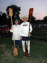
| Jeff Jouett and I at the start of the Colorado 100 |
 |
Gorilla tape is marvelous stuff but there’s a limit to what it’ll do when hastily applied to a wet rig. The limit in this case was about 100 yards. Hasty conversation to friends on the bank yielded a handful of zip ties which were good for about another 200 yards. Dark prospects, we are 99.9 miles more or less from the finish and the boat will not go in a straight line.
We decide to muscle our way to Smithville, the first checkpoint some 27 miles away and see if we can repair rudder then. The boat is dynamically unstable without a rudder, will not even consider going in a straight line. After trying several different techniques, the best we could do was to have Jeff paddle away dragging the boat along and I would steer with my paddle and take forward strokes when possible, which was every 4th or 5th stroke. It was a challenge to get to Smithville, being both harder and slower to paddle than any of the practice runs we had made. But we made it, almost 3 hours behind schedule. Along the way we had talked about different repair scenarios and decided it wouldn’t be that hard to make some new holes in the hinge, a piece of polypropylene plastic and reattach with the old fasteners.
This we did at the head of the island just downstream of the Smithville checkpoint after picking up a couple of multitools along with the requisite water, electrolytes and nutrition. After a half hour or more of fiddling work we were off and running. Much, much better than before thank you very much, we even whooped and hollered a bit at first because it was so much nicer to run down the river paddling in unison. Seemed almost like flying.
Now this article is not intended to be an expose of how to overcome trials and tribulations of my own making (for that I could probably start a weekly column). Due to a GPS there is some real hard data here on the merits of a rudder on a boat designed for one.
I had enjoyed Kevin O’Neill’s articles on charting GPS data and wanted to do something similar with boatspeed on a river course where the flow significantly affects boatspeed. My GPS, a Lowrance H2OC, records tracks (trails) without appending any time information and by default lays down points only when you change direction. But you can reset the trail update criteria to update at a set specified time interval. In this case a 6 second interval looked like it would work and cover the course without running out of points (9999 maximum).
So here is what the GPS showed.
First is a screen shot of the map data.
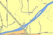 |
Map data - note the change in the path before and after the repair
click images for larger views |
The green line is our trail, we are coming from the left to the checkpoint just past the Highway 71 bridge. After picking up the multitools we went to the head of the island at the area called ‘Hunt Branch’. The island is shown as being somewhat downstream of where we stopped but was probably correct when some of the area was originally mapped. The thing to notice is the jagged path coming into Hunt Branch and the beautiful elegant smoothly flowing path the boat took when we left.
Next is a chart of boat speed from the start at Bastrop to the checkpoint at Lagrange. Smithville in at the area in middle of the graph with two stops and the little spike up that represents the paddle from checkpoint to the island. The other drops in the graph are other checkpoints and or pee stops.
Boat speed chart
click images for larger views |
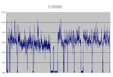 |
The data is probably not 100% accurate, my simpleminded approach to finding distance between points via Pythagorean Theorem may offend some purist, but its close and I’m more interested in relative rather than absolute figures.
The graph is interesting but doesn’t tell me much, but look what happens when we take a 20 minute slice of time from just before coming into Smithville and a 20 minute slice of time just after leaving the island.
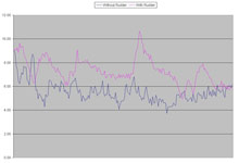 |
20 minute slices chart
click images for larger views |
There is a difference! Big difference. Most interesting is the predictable Ramp up of speed in the riffles and the steady decrease afterward (when your boat is responding). Its fun to have a new tool to play with and I’ll try to take a look at some more data when I’ve got some time but this looked interesting enough to share.
Cheers,
Skip
***** |