|
A while back there was a stimulating discussion string on the Duckworks Yahoo! forum on using sextants and some comparison of sextants vs. GPS. Emotionally, I come down on the sextant side of that debate. Intellectually, I will happily admit there are few nautical devices as handy, convenient and reliable as the modern GPS, particularly those with built-in charts.
But while pushing buttons and allowing microchips to chirp and gurgle their way to a nautical position fix may be quick and convenient and highly (but not totally) reliable, it isn't nearly as satisfying as hunching over a plotting sheet, penciling in position lines from sextant sights. Nor is it as fulfilling as swinging a sextant arm while squinting through it's scope and bringing a reflected image of sun, moon, planet, or star down to the horizon.
|
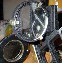
The plastic Davis Master 15 sextant. I think it's a 3x scope. The plastic is slightly less accurate than the metal sextant, but this will bring you home reliably. |
This isn't a treatise on how to use a sextant and "reduce" a sight. Rather it's some random thoughts on celestial navigation.
First let's explain what a sextant does. It's a nautical protractor. It measures the angle, with great precision, between a celestial body and the horizon. There's a moveable mirror on top of the sextant which reflects the celestial body to a mirror on the front of the sextant, which in turn reflects it back through to the scope at the back end of the sextant, to which is glued your eye. Since the sun is bright enough to quickly blind you, there are strong filters which can be interposed in this path which protects your sensitive optic nerve. The filters are obviously not needed when you're stalking the moon, planets, or stars. That front mirror (called the horizon mirror) is only a half circle or square, the other half of the framed circle or square is open so you can see the horizon beyond the mirror.
|
The horizon mirror from the metal Capet sextant. Half mirror, half clear so you can see the horizon beyond it. |
What you're doing with a sextant is bringing a reflected image, using the mirrors, down to the horizon. The top mirror pivots to do this and it's attached to a long arm that rides along an arced scale on the bottom of the sextant, from which you read the angle.
If you measure the angle above the horizon of any celestial body, wait a few seconds and measure again, you'll find a small, but noticeable change. That's a sign of how precise a sextant is, even an inexpensive one. It's also reflects this: If you fastened a string between the center of the Earth and the center of the sun, moon, star, etc., you're viewing, the point where it pierces the surface of the Earth would move a mile very four seconds. Obviously, the closer you are to that point, the closer the object is to being directly overhead and the larger the angle and the further away, the smaller the angle. And that point changes 15 miles every minute. This also explains why celestial navigators are such exact time freaks. If your watch or chronometer is off by a minute, you're resultant sight will be off by 15 miles!
|
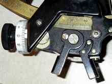
Reading the angle off the measurement arc. In this case it reads 68 degrees, 9 minutes. If you're fussy, you could call it 8.75 minutes, but, hey, who's going to be accurate to a quarter mile from the bouncing deck of a small boat! |
Enough numbers for a while. Now let's look at the plastic versus metal sextants. Some purists insist on metal sextants, the least expensive of which are many hundreds of dollars, while plastic ones can be had at a fraction of the price. I concur with the observation of author Donald Hamilton, who wrote in his book Cruises with Kathleen that the experienced sextant user will not have a problem with a plastic sextant, while a beginner will find the better optics, smoother operating and more precise metal sextant easier to use. Unfortunately, it's the opposite that usually happens, as the beginner (sensibly) is reluctant to lay out a pile of money for a metal instrument.
What you're giving up with plastic is some ease of use and some accuracy. The well adjusted metal sextant is going to operate more smoothly and being metal will be nearly impervious to temperature changes. Plastic will react to temperature and that will have a slight effect on accuracy. There's a thing called index error with sextants (it's not necessary to explain it here). On a metal sextant, the index error won't change unless you bang the sextant. With a plastic sextant, I found it changed every time I used it, and sometimes while I used it. This wasn't a large matter, I just checked it at the start and conclusion of a sight session and averaged the difference. Usually the change would make a difference in the final result of a mile or so.
(Okay, here's how you determine index error. Set the sextant to the zero angle. When you look through the scope/sighting tube, you should see a straight line horizon across the horizon mirror and the open part of the horizon mirror frame. Probably you won't. You adjust the sextant until it is a straight horizon and note from the scale how far off zero that is. Depending which side of zero the error is, you add or subtract that amount from your final sight to compensate. No biggie.)
The professed accuracy of plastic sextants varies. I first had a Davis Master 3 sextant. No scope, and a vernier scale that professed to be no more accurate that two nautical miles. I graduated to better Davis models, and still have a Master 15. It boasts an adjustment knob like metal sextants and professes an accuracy of 0.2 miles. Kinda funny since the variable index error obviates that kind of precision. My metal Capet sextant (I think it was made by Tamaya) is what is called a 3/4 yacht size, or slightly smaller than a normal full-sized sextant. It measures to the nearest mile although if you're finicky it's possible to extract a bit more accuracy from the scale. But despite the professed lesser accuracy, it is easier to use that the plastic sextants, has more powerful and better optics, and has superior repeatability. It is the more precise instrument.
Here are two other thoughts about plastic sextants and accuracy. One comes, again, from Donald Hamilton. And that is that true fractional mile accuracy with a sextant from the bouncing deck of a small boat at sea is illusional. And secondly, a way to compensate for the slight inaccuracies was hinted at above - averaging. Take several sights, which I tend to do anyway, throw out any obviously egregious errors and average the results. You can either work out the sights and average them or plot the sights on graph paper and then work out the most accurate.
Does averaging work? When teaching myself celestial navigation, I would go to the beach with the Davis Master 3, shoot a few sights, and then go home and work them out. It was a cause of joy if any single sight was close to the two mile rated accuracy of the instrument. After 40 to 50 sights, I decided to average them. The result - remember this was with a rookie user and a sextant accurate to no more than two miles - was a half mile off. Averaging negated all the little foibles of the plastic instrument. Obviously you can't take 50 sights every time you use the sextant, but a handful will do after you've gained practice.
|
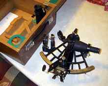
My all metal Capet sextant. Smooth to use, great optics (both a 4x and 7x scope), great repeatability. |
Now that you've actually taken a sextant sight, what do you do?
You reduce it, of course. There are three options.
The first is a traditional way. You get an annual nautical almanac and the sight reduction tables and work out the sights on paper. That involves calculating the corrections to the sight on paper, an easy job. All the hard math is done in the sight reduction tables. You look up some figures in the tables and you get your answers. With practice, this takes about five minutes or less per sight.
The intermediate way is to get the trigonometric sight reduction formulas and use an electronic calculator, which dispenses with the sight reduction tables (but not the almanac). A scientific calculator, with sine, cosine and tangent functions, is the minimum requirement. You'll have to convert your measurements in degrees and minutes into degrees and decimal points, but that's not hard. Back in the mid 80s I had one of the first pocket computers, which boasted a staggering 4K of memory. But it had all the scientific functions and the memory would retain a program when turned off. I wrote a simple program
(about 1K in length - my sole foray into computer programming) so all I had to do is punch in the numbers and the result would spit out. I felt soooo modern. I did still do the corrections to the original sight by hand, since it was just about as fast as punching numbers into the calculator. This calculator also offered the luxury of accepting inputs and giving answers in degrees and minutes; no conversion to decimal degrees was necessary.
The third option is to obtain a full blown nautical calculator. These have the nautical almanac built into their memories. Some even have built-in clocks. Once some basic information is plugged in (no need to convert to decimal degrees), all you have to do is hit a button on the calculator to tell it the time the sight was taken and punch in the reading from the sextant and - presto! - it churns out a position line. Most of these wonderful machines will even take several different sights and give you a position fix as well as calculate the course and distance to your destination. You don't even have to buy a dedicated machine. I found a fairly inexpensive program a few years ago that was designed for Palm Pilots (and I just picked up a used unit that runs the program for a bit more than six bucks, including shipping). There used to be - and may still be - a program available that loaded into advanced scientific calculators, the ones that have a built in memory and typically go for $80 to $100. And yes, according to a Google search, you can download an app for your smart phone or smart pad. It can, in a case of technological incongruity, snuggle in the memory right next to the built-in GPS with its maps and charts.
However, a word of caution about the technological marvels. The nautical almanac contains a huge amount of data - and that's only for one year. Remember that example about the line stretched from the center of the celestial body and the center of the Earth and the spot where it pierces the surface of the Earth? Well, the almanac has data so you can figure out where that spot is for the sun, moon, planets, and navigable stars for every second of every day for the entire year. There's some shortcuts that cut down on the almanac size, but it's still an impressive amount of data. Now the early calculators, even the expensive ones, didn't have that much memory by today's standards, and certainly not enough to cover the 50 or 60 years these calculators claimed to be good for. So what they resorted to were algorithms. But algorithms rely on averages and don't have the detail or account for variations of celestial bodies' movements that are included in the almanac.
I have a book on using calculators for celestial navigation that had a modest chart - about 2K in size - that could be programmed into a pocket computer and would serve as a sun almanac. But there was a warning that it could introduce an error of two miles or so into the result - not too bad in most conditions. I've also read an account of someone using one of the early advanced calculators (this was 20 or so years ago) and thinking one of his mid-ocean sights didn't look quite right. So he worked it out with the almanac and tables and got a result that was something like 16 miles different. The next day, the calculator was perfectly accurate again.
I'm assuming the modern computer iterations have worked out most of those bugs, especially since they have virtually unlimited memories by the standards of 15 or 20 years ago. But you never know. . . . My Palm Pilot program has seemed perfectly accurate to date.
Okay, there's only a few more points to cover. One is on corrections to the sextant sight, which have been referred to previously but not really explained. These are adjustments to the raw sight to take into account different factors. Already mentioned is index error. Another is your height above the horizon. The higher you are, the further the horizon and that affects the angle you measure. So there's a correction for the height of your eye above the horizon. The atmosphere distorts the image of the sun as it passed through, although the higher the sun the smaller the distortion. So there's a correction for that. When you shoot the sun or moon, you bring either the upper or lower edge even with the horizon in your sextant, rather than try to guess where the center is. So there's a correction for that. On a moon site there's something called parallax error that must be adjusted for. There's even a correction for barometric pressure, but it's so insignificant that it can be ignored, unless you're shooting with a giant sextant, mounted on a tripod, from the deck of an aircraft carrier in a dead calm sea.
You may have noted a reference earlier to the result of a sextant sight will be a position line. That's right, a single sight gives you a line, and you're somewhere on that line. A sight does not give you a pinpoint fix. You need position lines from two different bodies that cross at a decent angle to get a fix. The sun and moon are visible at the proper angles about 10 days a month. Or you can shoot as many planets and stars as possible at dusk or dawn while both they and the horizon are visible. (No, the multiple position lines won't cross in a single point but if you're lucky it will be a very small area. . . .) If all you have is the sun, wait a few hours and then shoot another sight. If you've sailed 10 miles due west since the first sight, move that line 10 miles to the west on your plotting sheet and then see where the new sight line crosses it. It's called a running fix and is how most sextant navigation was done.
Now let's look at books. Everyone has their favorite book and there are many out there. Mine is Hewitt Schlereth's Commonsense Celestial Navigation. It's out of print, but used copies are available through Amazon.com, and probably eBay. I can't speak for others because I discovered Schlereth early and haven't bothered to look at most alternatives. It's a very straightforward, readable explanation of how to do celestial navigation. Schlereth begins with the sun, and expands to the moon, planets, and stars. Taking and reducing the sights are clearly explained, as is using the sight reduction tables. He also likes plastic sextants.
A definite bonus is the book includes a perpetual sun almanac, the formulas needed to reduce the sites without the tables, and a complete set of sine and cosine tables which make using the formulas easy. The perpetual almanac won't be as accurate as the annual nautical almanac, but it will be close. What it means is that with a sextant, watch, and this book, Schlereth has given you a way to reduce any sun sight. It's worth carrying aboard just for that reason as it becomes a compact backup if your GPS fails.
Now let's finish up this little treatise with a story. In 1987, I set out for a shakedown sail on my newly built 30-footer. It was the first time I had been offshore alone. I left in the evening and shifty winds required a series of course changes, not all of which got logged. So soon, I only had a vague idea of where I was. Not a big deal, there was a lot of open Gulf of Mexico water around me and there wasn't any danger of hitting anything solid.
The next day, sextant sights were taken in the morning and I sat down with my pocket computer, carefully programmed to reduce sights, and the nautical almanac - and the results were hundreds of miles off. Somewhere near the Mexican coast instead of the Big Bend of Florida. I scratched my head sailed on, and shot more sights in the afternoon, with the same result. Baffled, I sailed on, my exact position becoming ever more vague. (I couldn't afford a loran, which anyway was a pretty bulky piece of equipment in those days. I did have a radio direction finder, but the two nearest stations were on nearly reciprocal headings and not well situated to help.) It turns out the pocket computer could be set to do its calculations in degrees and in something called gradients and radians. It had accidently gotten switched to one of the latter two, although I didn't discover it until ashore (it had never happened before).
By the third day, I was heading back and said the heck with electronics. I pulled out Schlereth's book (yes, I should have used it before but was reluctant to abandon my electronic toy and was slow to realize the problem wasn't with the sights) and used it on a fresh set of sun sights taken with my plastic sextant. Joy! They were all bunched within a couple miles and I had a position line. A couple hours later, another set was taken, also satisfactorily close together and I had a second line. The first line was advanced and I had a running fix. This part of the Gulf is dotted with hundred foot pillars that the Air Force uses to calibrate the navigation gear on its jets. I was getting ready to shoot more sun sights in the late afternoon when I looked out and there, exactly where it should have been if my earlier sights were correct, was one of the pillars.
No subsequent navigation feat with a handheld loran or GPS has ever given me the satisfaction of that celestial success.
|