A Small Boat Cruising Primer for the Brave, Hardy,
or Foolish
Week 3—Cape Roberts to Drummond Island Yacht Haven
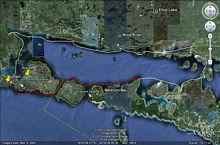
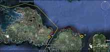
So, the final week of our journey; I’d given myself four weeks, and it was beginning to look like we’d make it. The image above shows the North Channel at the northern edge of Lake Huron. Our 20-day journey began at De Tour Village on the eastern tip of Michigan’s Upper Peninsula, and finished on Drummond Island. The line in white shows our progress for the first two weeks; the red line shows our final week of sailing.
Day 15: CapeRoberts to the Devil’s Horn (22 miles)
The southern edge of the North Channel now, sailing along the shore of Manitoulin Island. No more dramatic landscapes and rocky coves—instead, long unbroken stretches of flat wooded shoreline with hardly any development; not so much wilderness as an air of gentle abandonment, a territory slowly erasing the obvious marks of civilization. But maybe the flat monotony is more a reflection of my state of mind. Having turned the corner and begun to close the loop, I’m caught up in a strange and paradoxical haste to return, to sail back into the harbor I started from, complete my first ambitious journey by sail and oar.
The day is overcast and gray, a chilly southeast wind egging me on to an early start. I put on my drysuit, drag Jagular out into knee-deep water, and start sailing east, broad reaching and running all day, the boat lively and fast, the unreefed lugsail at its best, the wind strong enough to be invigorating without threatening disaster, ending with a long hop across the Mississagi Strait to the easternmost point on Cockburn Island, the ominously named Devil’s Horn. During which, I learn:
1) I can sail alone all day and never be bored.
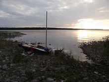
Jagular at the Devil’s Horn—more picturesque than threatening, it turns out.
DAY 16: The Devil’s Horn to DrummondIsland (13 miles)
Crossing back into US waters, I have a choice: go around the north side of Drummond Island, or make a longer trip around the southern tip. My friends from the Whalesback Channel did invite me to stop in at their house on my way past. Directions? Vague: the southern side of Drummond Island. I delay making a decision until I’m across False DeTour Channel, aiming farther north than I should if I decide to go south, and farther south than I should if I decide to go north. The worst of both worlds. But it’s a beautiful day, even if the wind dies down in the afternoon, leaving me rowing again.
Turns out the magical Pilot Cove campsite, the main attraction to the northern route, is taken by motorsports afficianados. South it is! Which shows me:
1) The eastern shore of Drummond Island is remote and rocky—my kind of place.
2) I’m probably going to make it back to my car.
3) There are plenty of potential campsites on the northern part of the eastern shore. Too bad it’s illegal to take one, since I haven’t cleared Customs yet.
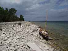
Landing in the US is illegal until you’ve cleared Customs; this boat on the rocky eastern shore of Drummond Island bears more than a passing resemblance to Jagular, but we won’t be clearing Customs for a few more days—no going ashore for us.
Day 17: The Devil’s Horn to the southern shore of Drummond Island (5-7 miles)
Morning comes in with a misty rain, and with the end so close, I’m wavering between being eager to finish, and lingering to enjoy my last few days. Meanwhile, we’re still barred from coming ashore until I clear customs. If I had been able to camp ashore legally last night, I might have ended up in a campsite like this:
And I might have spent a couple of hours exploring the island. The western end of Drummond Island is fairly remote and road-free, with the only access provided by 4x4 trails; jeepstering is a popular past-time. There are no houses or even roads on this stretch of shore, just forested bluffs recovering nicely from 19th century logging operations. If I had been able to come ashore and wander through the forests a bit, I suspect it would have looked something like this:
But instead, we found ourselves halfway down Drummond Island’s eastern shore, rowing southward through False Detour Channel—into a south wind, of course. The rain let up some, so we got moving; a few miles down the coast, the rain returned with a vengeance. Cold rain, headwinds, and the minor unpleasantries that seem to add up to memorable experiences. We did manage to keep our spirits up:
Waves were biggish by the time we rounded the southeast tip of the island, and the rain had soaked through my fading morale and left me cold and fighting off bouts of shivering between rowing stints. Not making much progress, but with nothing better to do we kept on, heading west along the southern shore now, fighting big rolling waves that would have been frightening to sail through. I’d have tried anyway, but the wind had bent itself tightly around the point to follow the shore, leaving me facing a stiff westerly now when a southerly would have been just right.
One thought occasionally broke through the gloom of endless windward rowing in the rain: somewhere up ahead, if we were lucky, we just might run into our friends from the Whalesback Channel. I knew the house was on the water, on the southern shore of Drummond Island. Every time I rounded another point of land, I’d scan the new bay closely, hoping and shivering. And then, a few hours into the day’s miseries, I spotted a familiar boat:
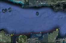
Hugh’s boat, moored to a floating dock at his DrummondIsland home. A welcome sight on a rainy day! (For privacy’s sake, I haven’t marked the location on the Google Earth image).
Here’s how I imagine things might have turned out, if only it would have been legal for me to come ashore:
Having suffered enough, I would have dragged my boat ashore on Hugh’s land and poked around a little. If no one was home, I’d have decided he had meant it when he invited me to stop by, left a note on his door inviting him to boot me off his land if he didn’t want me staying there, and found a spot to set up my tent and get out of the rain. Next I might have wandered through the forest picking raspberries and shivering. Within a couple of hours, though, Hugh and Julie would probably have returned with a boatload of guests, and I’m sure they would have proved to be gracious hosts indeed—a hot shower, a comfy armchair with shelves overflowing with good books, a tasty supper and magnificent breakfast the next day.
I would have looked around while waiting for my friends to show up; it probably would have seemed like my kind of place…
So, what did I learn?
1) The last few days are the longest—especially when they’re rainy ones.
2) If you want to stay legal and take the southern route around Drummond Island once you hit US waters, you have to be prepared to sleep on your boat until you hit Customs.
3) Not everyone chooses to stay legal, I suppose; sadly, there are far too many scofflaws among us.


-wr-wr.jpg)
-wr-wr.jpg)
-wr-wr.jpg)
-wr-wr.jpg)
-wr-wr.jpg)