
 Custom Search
|
| sails |
| plans |
| epoxy |
| rope/line |
| hardware |
| canoe/kayak |
| sailmaking |
| materials |
| models |
| media |
| tools |
| gear |

| join |
| home |
| indexes |
| classifieds |
| calendar |
| archives |
| about |
| links |
| Join Duckworks Get free newsletter CLICK HERE |
|
|
| Lake Powel Adventure - Part One |
by Sandra Leinweber - Harper, Texas - USA |
| Part One - Part Two - Part Three Reprinted from Messing About in Boats, Volume 22 - Number 16, January 1, 2005, pp. 12-15. Our first brief encounter with Lake Powell was two years ago mid-September. We had stayed in a cabin at the North Rim of Grand Canyon, and even though we were anxious to be home after almost a month on the road, we decided to make a side trip to Page where the Glen Canyon Dam and the southern end of Lake Powell live and breathe. Crossing over the top of the dam, the small bit of lake we could see suddenly became much larger when we realized the boats below were actually 50' houseboats. From our vantage they looked more like toys. We toured the Visitor Center, looked around a bit, and vowed to return with a boat. We also made a side trip to Lee's Ferry, the spot on the Colorado several miles below the dam where rafts and dories depart for trips through the Grand Canyon. Watching them float away, packed with people and their gear for a week, 10 days, two weeks, we wished we were on board. What a trip! Two years later we found ourselves back at Lee's Ferry waiting for our friends, Craig and Linda Anderson, to arrive. They live in Seattle and this was more or less halfway for each of us. We wanted to show them the big rafts and, of course, the river. It runs swift and cold here, the water is coming out of the bottom of Lake Powell. You can put a small boat in here and go up the river about 17 miles to the bottom of the dam. You cannot go the other way (towards the Grand Canyon) without a permit. We talked briefly with a ranger who was on his way to a plane crash (there went the idea of taking a plane ride over the canyon). He told us that there was a 17-year wait for a permit for a private float trip through the Canyon. I don't know how accurate that was, but just the idea of planning something that far ahead with any sort of reality was more than I could grasp. Chuck pointed out that you could always sell your permit on E-bay. Whatever! Our friends were late, partly a function of the weirdness of Arizona in not recognizing Daylight Savings Time, and we got to worrying since we had no signal on the cell phone and the sign pointing down to Lee's Ferry is easy to miss. The rafts had all left by that time, so we drove back up to the highway and met them there. We had already made reservations at the campground at Wahweap, and we all went there and set up our gear. Craig and Linda wanted to do a little tourist stuff before heading out in the Ladybug. We took the Antelope Canyon tour, a slot canyon on the Navajo Reservation. Below is a description I found on the web.
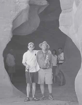
It is like walking through a cave with a narrow opening to the sky above. I had my doubts about the "tourist stuff," but this was worth the money despite the inevitable names that are given to rock shapes and the rituals having to do with sunrays and tossed handfuls of sand. We heard the story of the group of international tourists who were caught in the canyon by a flash flood. Our guide described their experience as "like being caught in a violent cement mixer, full of rocks and sand and water." None survived and the bodies that were recovered had been stripped of clothing. Apparently the canyon changes a good deal with every flood. The floor of sand may be several feet higher or lower depending on the force with which the water travels through. Trees carried by the water lodge in the convoluted sandstone of the walls. Everyone, including me, took pictures. Most of mine were either too dark or too light. One does show Chuck and Craig standing in the entrance to the slot.
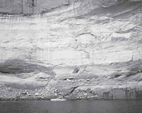
The lake was still quite low, 120' below normal to be exact. Not having ever seen it full I could make no comparison, but I could imagine by looking at the white line high on the rocks, calcium carbonate left by the receding water. The ramp at Wahweap was open but the ramp at Stateline was closed, nothing but sand and mud beyond the end of the cement. The Park Service plans to extend it but time and money make the process necessarily slow. We used the "alternate ramp" at Stateline. Thank goodness the Ladybug is easy to launch. We really just need a bit of a slope, firm ground (not always easy to find), and a couple of feet of water. The low water level meant that now there was only one way to go, up the lake through a passage called The Narrows. This is a relative term, certainly there is room for huge houseboats and all the other varieties of watercraft, including jet skis. The walls of the canyon are high and rise straight up out of the water on either side. The part we had not anticipated was the condition created when all those different boats were coming and going at the same time. It was Labor Day weekend and there were many boats, both coming and going. Each seemed to create the maximum wake by going just fast enough to plow the water into waves, waves that spread out and bounced off the walls of the canyon like the notes of many different musical tempos. You would almost think that all those different wakes could come back together and combine to become smooth, maybe 2' higher than the actual water level. I must have been delusional to even imagine that! It was pure chaos for the poor Ladybug. With her little two horse outboard and four bodies aboard instead of the usual two, she began to flounder. It made me think of a bathtub full of rambunctious babies, all slapping the water with their palms and laughing. There was no discussion, we simply turned around and headed back for the calmer waters of the bay. A short distance under those conditions would have been one thing, but 18 miles? No photos here, I was holding on tight. We found a beautiful little cove for lunch. The water was cool and clear and impossible to resist. Unless you were Chuck. We never did get him in the water. We swam, hiked around, and napped on a ledge in the shadow of an overhang. Later, motoring along, watching the birds, avocets, and coots, we kept our eyes open for a nice spot to spend the night. One spot we looked at had springs coming out of the rocks above the beach. In places below the springs the sand and mud had become quicksand. Don't ask how I know that. More than once we landed only to sink almost knee deep into mud upon stepping from the boat. Anyplace that mud was washed down from above and collected would be like that. I am told that when the lake was full, sandy landing spots were quite rare, that rocks were pretty much the rule. This particular afternoon all the really classic spots (narrow sandy beaches under a huge overhang) had already been claimed by houseboats, but we eventually found a nice slightly sandy, mostly rocky beach where once landed, we became truly insignificant as we were under the towering majesty of Castle Rock. By the time we had our tents and our little privacy tent for the porta potti set up, it was time to cook dinner. I got to test my new water purifier that is guaranteed to filter out EVERYTHING BAD. Everyone looked a bit dubious when I plopped one end in the lake and screwed the other to my water bottle. A few pumps and we had perfect water. They made me drink first, a silly test, but it seemed to reassure them. After dinner we watched the sunset and waited for the stars to come out. To be continued... |
|